Comments
Porcupine224 t1_iueq359 wrote
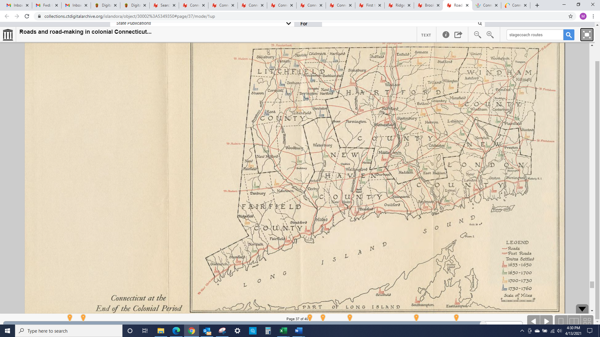
Some observations as someone who isn't well-educated in CT history at all:
-Southington is nowhere to be found; further reading shows it was the "South Society of Farmington" until being an official town in 1779.
-The clear pattern of older cities surrounding the waterways and expansion going further outward from there can be seen by the years of settlement.
-"Saybrook". Just that.
-The almost uniform boundaries of Litchfield county at the time. Like there was a concerted effort to split the county evenly into towns all at once.
-How recently the towns we know of and think of as staples of CT were formed based on just being separate neighborhoods that declared township.
-Tolland and Middlesex counties don't exist.
-Beginnings of I-95 and I-91 are obvious. The route I-84 eventually creates isn't present.
As a map nerd, old maps like these are sooo interesting. Thanks for sharing!
HellfireMelvin t1_iuesn54 wrote
Take back the notch!!!
CTHistory42 OP t1_iuev6cn wrote
Sorry, I don't. But I can tell you that stagecoaches were running from 1783 to 1850.
CTHistory42 OP t1_iuevawm wrote
Ah, you picked it up from the URL in the photo
TheRealGodHatesFigs t1_iuf28wb wrote
The Southwick jog (aka "the notch") wasn't formalized until 1801 so if the map is accurate, it would be dated to before that point.
[deleted] t1_iuf2llk wrote
[removed]
TankGirlwrx t1_iuf3wv7 wrote
I’m not sure if it’s just a quirk of whoever labeled this but Middle Town makes me kinda giggle. “Oh, here’s a town in the middle…what a great name!”
Slight-Possession-61 t1_iuf4qli wrote
No Wilton?
No loss….
Few-Information7570 t1_iuf4wbk wrote
Very cool. Here two is a later map where Wilton has been formed and east and Weston have been split off from Fairfield.
https://whereilivect.org/wp-content/uploads/CT-Stagecoach-route-map.pdf
Few-Information7570 t1_iuf62bu wrote
Here’s a bit on our steamboat history: https://www.ctexplored.org/full-steam-ahead-steamboat-travel-in-connecticut/
And somewhere too there are old adverts for the Norwalk Wilton and Ridgefield stagecoach that was timed to coincide with the steamers heading to New York.
IGameOnMac t1_iuf6rtc wrote
Ah… before 1821… my major city… Bridgeport hasn’t popped up yet either
Someone mentioned southington is no where to be found… founded 1779 so before then I assume
IGameOnMac t1_iuf77fu wrote
Bridgeport exists… and it’s in bold letters to indicate it’s city status!
Few-Information7570 t1_iuf8ci7 wrote
And we still have interesting issues with borders. Could black rock go back to being part of Fairfield? On Ridgefields east side, Lewisboro could easily just be an extension as it was before it was ceded to NYS. Interesting stuff.
imjustaidan t1_iuf95t7 wrote
I might be bad at reading maps but it seems that the route from new Milford to new Fairfield would be impossible now because of candlewood lake, which was made in 1928. Crazy how something so big and such a staple of the area is man made.
IGameOnMac t1_iuf99cz wrote
Oh… and let’s get back long island… only… that’s three times our population right there and they wouldn’t like being ruled from hartford
neurocellulose t1_iufd9pn wrote
It's from 1933, part of the lead up to the Tercentenary of the state. Some of the omissions are odd but I think the lack of town-by-town resolution is for the sake of clarity.
SAM-in-the-DARK t1_iufhtez wrote
This is very interesting. Thank you.
billdf99 t1_iufjp95 wrote
Really interesting observations. Thanks for sharing.
I think I CAN make out 84. Follow the road from danbury to Newtown to Southbury to Waterbury to Hartford. This map isn't exactly correct so it's hard to follow, but I think that's the general path.
NerdDruggist t1_iufm6fd wrote
I’m curious what the different colors for the churches signify.
Edit: sigh, if I had looked at the legend, I wouldn’t have had to ask
fekinEEEjit t1_iufq0c6 wrote
They are mocking us with this map...political torture...
fekinEEEjit t1_iufq72j wrote
New London Turnpike from Gbury to the southeast!
[deleted] t1_iufuglk wrote
[deleted]
smartypants4all t1_iufvrc8 wrote
I am pretty sure that Route 44 follows that same path through the NW hills and into Hartford.
Porcupine224 t1_iufvw89 wrote
Yeah, you're right I can see it. I was more commenting on how 95 and 91 already appear as "major" roads at this time. I definitely would have thought 84 came before 91.
roubaixSport t1_iufw19l wrote
Midway between Saybrook and Hartford.
CTHistory42 OP t1_iug36z5 wrote
Thanks for that!
CTHistory42 OP t1_iug40tm wrote
Great article! And yes, the stagecoaches were timed to coordinate with the steamers so that, for example, someone going from Litchfield to New York City had to start off at 3 am to take the stagecoach to Norwalk. But, they could get back home the very same day, if their appointment in NYC was in the morning.
CTHistory42 OP t1_iug456a wrote
I'll have an episode upcoming on the creation of Candlewood Lake. It's a simply incredible story.
CTHistory42 OP t1_iug474v wrote
You're welcome!
CTHistory42 OP t1_iug4d08 wrote
Fairfield was one of the first settlements in CT - and yes, it was huge and gave up land to form a number of its (today) neighboring towns.
CTHistory42 OP t1_iug4h7i wrote
You're absolutely welcome!
Few-Information7570 t1_iug7iyt wrote
That I did not know the actual timing but I assumed it was an arduous and long journey!
CTHistory42 OP t1_iugc0og wrote
Just for the record, New Milford is still the largest town in CT in terms of acreage. However, it did not give land for the formation of Sherman. That distinction falls to New Fairfield. They did give land for Bridgewater though.
Personal-Ad-7407 t1_iuggd7z wrote
Another fun look is Windsor, which later splits into Windsor Locks, East Windsor and Ellington. Later, South Windsor splits off from East Windsor.
On this map, Windsor is on both sides of the CT River. Am I correct that Haddam is the only town that still is on both sides of the river?
realbusabusa t1_iugn2yo wrote
More like proto Rt 1 & Rt 5 than 95 & 91 but yeah
billdf99 t1_iuha62w wrote
I see what you mean. I'm not sure the order the highways were built. I think 84 was a little later though.
infiniZii t1_iuhgsck wrote
I'm pretty sure Naugatuck existed at the time of this map. The river was the Naugatuck river but the borough isn't listed. It was tiny at the time though so they probably just didn't include it.
CalligrapherDizzy201 t1_iuhk26n wrote
An infuriatingly tiny part of Wethersfield is between East Hartford and Glastonbury. You can walk through it on the Goodwin University river trail.
GunnieGraves t1_iuho7ig wrote
Love how large Windsor was before they parceled it out
Personal-Ad-7407 t1_iuhr8fd wrote
Interesting!
That is a strange jog in the border. I checked the Wethersfield GIS map to be sure it wasn’t a Google Map artifact. Great trivia question material.
CalligrapherDizzy201 t1_iuhrr39 wrote
It’s really cool to walk through the woods and see an East Hartford/Wethersfield town line sign followed, about a half mile later, by a Glastonbury/Wethersfield town line sign. There’s even a reason for it but I don’t remember what. I’ll go look and update.
ETA: https://www.realhartford.org/2019/09/18/east-of-the-river-to-wethersfield/
Turns out it was a flood. This is a cool article about the area.
wremt t1_iuhu8ks wrote
I hope it covers the Black history of former town of Jerusalem. Would love to hear it!
redcapmilk t1_iui9ybg wrote
If we take back the notch we get Southfield and that's not so bad, but then we'd be touching Wastefield, and I'm not about that.
CTHistory42 OP t1_iuik9qs wrote
Some people aren't aware that Windsor was the very first settlement in CT
singalong37 t1_iuil4b0 wrote
Hartford might be in better shape today if West Hartford, East Hartford and Manchester were all still part of Hartford.
UnitDogeX t1_iujjrv1 wrote
Yeah, but I just wonder how come they break up into smaller towns and stuff.
CTHistory42 OP t1_iujl1zf wrote
In those days, the primary reason was that it was too long of a horse and buggy ride on Sunday to attend church - or, during the week, to do business.
zgrizz t1_iuek1qd wrote
That's really cool. Thanks!