Submitted by visualgeomatics t3_11qxfc5 in dataisbeautiful
Submitted by visualgeomatics t3_11qxfc5 in dataisbeautiful
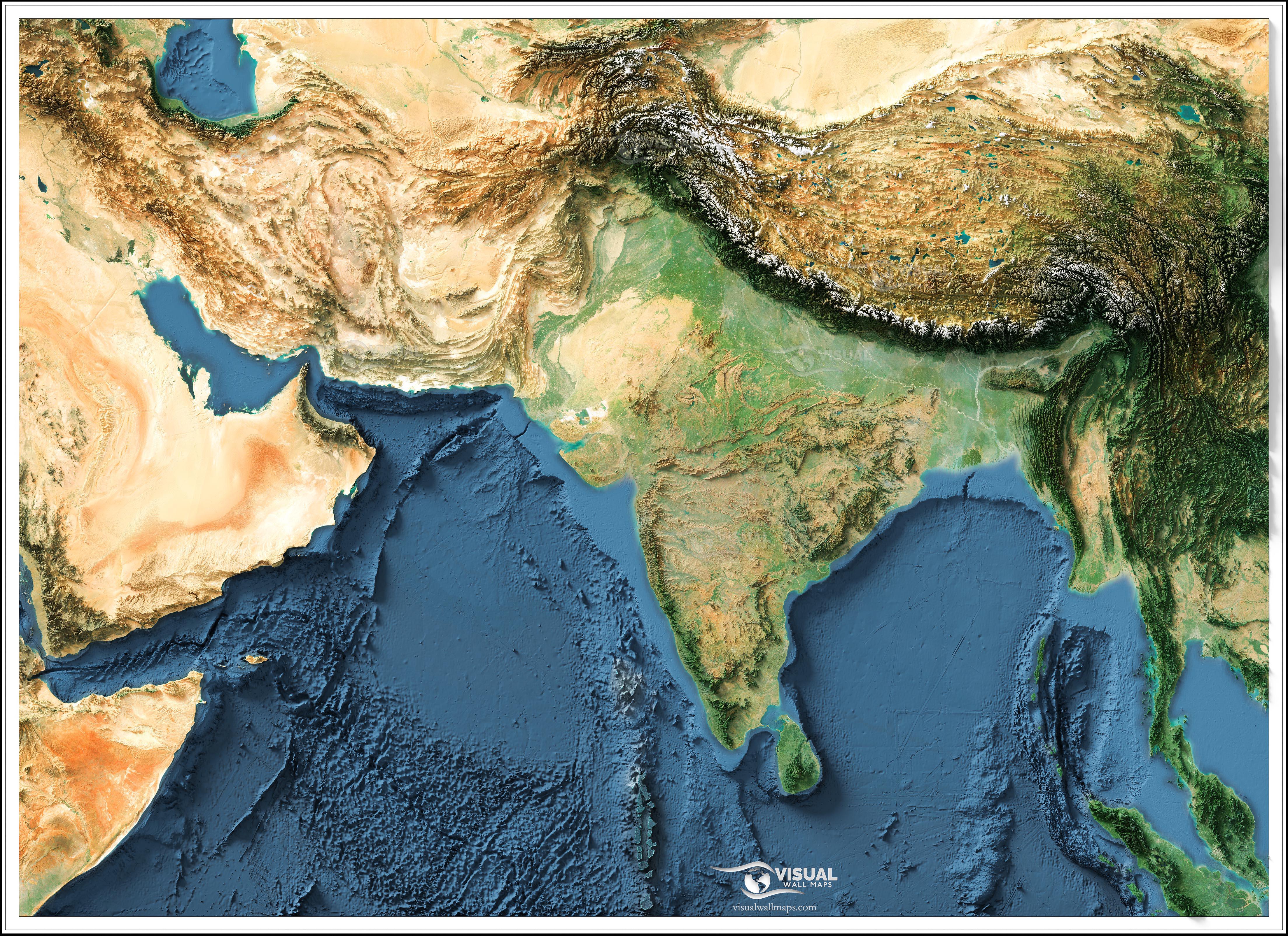
Very nice, it's amazing how the Himalayas is just crumpled ground from the Indian plate smashing into the Asian plate.
I never noticed Arabian Peninsula was this close to India
So... Does this make India the Florida of Asia?
[removed]
[removed]
Living in Georgia, I only wish we had the Himalayas separating us from the hot mess that is Florida.
[deleted]
OK, now do the seaweed monster that's about to eat Florida.
You can see the ongoing collision of the Indian subcontinent into the Asian continent creating the Himalayas, fun fact: they're still getting bigger; Everest gets a 1/4th of an inch (6.35 mm) taller every year even with solar and precipitated erosion.
So every person who summits Mt. Everest is technically setting a new record.
Interesting how the Indus and Ganges rivers seem to cut right through the continental shelf, like they keep flowing once they hit the ocean. Also interesting how the Shatt al-Arab (Tigris/Euphrates system) does not do the same.
“Now kith”
-Plate tectonics, probably
I'd speculate this points to where the coastline was previously, perhaps during the last glacial maximum
>By 1967 most scientists in geology accepted the theory of plate tectonics. The root of this was Alfred Wegener's 1912 publication of his theory of continental drift, which was a controversy in the field through the 1950s.
Surprisingly recent.
Nice. Shame the watermark is right in the middle of the area that interests me (right in the middle of the Ganges valley). Designed to ensure Indian's can't use it?
I was taught earth science by one the originators of tectonic plate theory, back in the 1980s.
Yep. There was maritime trade between them dating back to the origins of civilisation: thousands of years.
I never realized how steep the Himalayas were from the South.
You make the Himalayas sound delicious
What are the almost concentric five rings on the Indian plateau?
How do they even measure that?
Short Answer: GPS, I can explain further if you'd like?
The watermark?
Well what amazes me is how they pull off such accuracy.
Multiple readings utilizing multiple satellites throughout the year.
Can anyone explain the geological reason for the desert/dry area in north-west India?
What causes that?
Wow! The Himalayas just straight up draw a line between India and Tibet.
Minimum of 4 satellites at any time baby
Aravalli Ranges. The desert lies in the rain shadow region. Monsoon rains are blocked by the mountains.
Thank you!
No,not that.
Zoom in to Central India. Five almost concentric raised elevations. Very big. Two side by side. Another pair below these. And one below these middle pair.
Almost like craters, but huge.
Except that if you put the boundaries in the map, you will find that many Indians states go well into the Himalayas. Ladakh, Himachal Pradesh, Uttarakand and Arunachal Pradesh come to mind.
Dunno, I don't see what you're talking about
Very impressive, a truly beautiful rendition.
Can I ask - Is it expensive to buy the Sentinel-2 imagery?
Yeah, I think the final nail in the coffin for those resisting it was when we finally got good data on the details of the sea floor and we could actually map out the forces that were driving plate tectonics. Also, science in general can be held back by older generations resisting new ideas. IIRC the theory of part of the heat in the Earth's core being caused by radioactive isotopes was basically dead in the water because Lord Kelvin refused to accept it, and his death finally allowed people to really start arguing for it.
Isn't it crumpled ground from the Asian plate as a result of the Indian plate jamming underneath?
IIRC, the Himalays are both the Asian and Indian plates crumbling. There're three types of plates touching: convergent, divergent, and transform (towards each other, apart from each other and alongside each other). There's two types of plates: continental and oceanic, of which the latter is much lighter .
The Indian plate and Asian plate are convergent and both continental. That means they generally just smash into each other, i.o.w. both crumbling. If one of them was oceanic, say Asia and the Pacific, the oceanic one would sink under the continental one, creating a valley or (Mariana) trench.
Amazing. What conditions are stopping Yemen and Oman from seeing the same level of greenery as India? I don’t see any obvious geographical obstacles to the rainfall that is clearly falling on India.
You can download individual tiles for free but for large areas like this it would take quite some time to mosaic and clean seemlines. I purchases the eox cloudless dataset for the globe, it definitely wasn't cheap but I can map any area pretty quickly with it.
I'll second both of you. It's the cut from when see levels were lower and it's freaking cool.
I appreciate the info, thanks!
What’s with the triangle and near-perfect straight lines on the ocean floor east of India?
They drop a string from the top and measure the string!
Yea it’s another conspiracy against Indians to keep them from achieving superpower status.
The low pressure region that forms over tibet during summer draws the monsoon winds from the Indian ocean towards the subcontinent, that being the main reason.
Also Oman does receive some rainfall which turns parts of it green but not as much the subcontinent.
Areas that have been traced by deep sea submersibles. So basically the path of those vessels. Other parts of the oceanfloor haven't been traced hence blurry.
visualgeomatics OP t1_jc5lzem wrote
Source: GEBCO DEM, Sentinel-2 satellite imagery
Tools: Blender, QGIS, Global Mapper, Photoshop
Description: I combined sentinel-2 imagery with surface model data to cast light on it and create a pretty image that looks 3d. The map has lots of vertical exaggeration to bring out the topography, and I've coloured in the water, otherwise the image is a natural colour representation! Check out other examples on my instagram