Submitted by Specialist_Cow2011 t3_10l53vv in dataisbeautiful
Submitted by Specialist_Cow2011 t3_10l53vv in dataisbeautiful
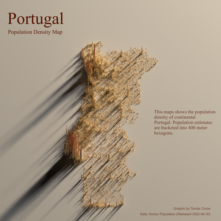
Very surprising how empty the south is
Also really eye opening to realize how much of the population lives in cities, like just these huge spikes followed by nothing until you reach another city
The U.S. is the exception in that it does have lots of "in-fill"--loads of suburbia and strip malls in between big cities. A characteristic of a society designed around cars.
Most of the world is characterized by wide open space and long roads until your reach the next city, town, or settlement.
Need a higher res version, once you zoom in everything gets fuzzy. Other than that its great!
Are you Tomás Coroa? where can i see more of his graphics? if theres more
Half the country's population lives in the Metropolian Areas of Lisbon, Porto, and Faro.
That's because the south is a deserted area - dry and warm. And the northeast, a mountainous region.
Also, naturally, most dense cities lay on the coast.
That really depend on what part of the US you're talking about. You have huge deserts, lakes, and mountain ranges. No 'in-between' cities as well.
This is the same, only at a much smaller scale, since it's a small country.
Portugal has a lot of small/medium cities (with hundreds of towns in between) but only a few big ones, so it skews the results on the graph. Making it seem like there are more deserted areas than there actually are.
[removed]
Did you mean "400 meter squared"?
I am but this is the first one I've made! You can follow Tyler Morgan-Wall on Twitter, he's the developer of the package and has tons of awesome graphics :)
For sure! This is merely a screenshot, I tried to post the original png file but it's too large :/
Indeed! Thank you :)
“Portugal Population Density Map, represented on a teenagers used Bioré strip.”
r/TIHI
JK, well done!
This is awesome, thanks for the info on the R package!
Where is the rest of Portugal?
I actually just started learning R. Can you point me to the resource(s) you used to learn?
As in the Spanish map, the islands are missing. Why do you guys from the continent always forget about us?
I absolutely love this type of map, well done
Wow, they have a lot of Skyscrapers in Portugal.
[removed]
I’d love to learn how to do this for each estate in the USA. What do you suggest I use to create that? Software… programs..?
He’s an absolute legend. I’d love to shake his hand one day.
Love it. Plus learned of a new package.
I mean it looks cool and all but I can't help feel another more simple map might convey the information better.
Azores have left the chat…
[removed]
[deleted]
Is it just me or does it look like someone made the Pillsbury Doughboy out of sand and then ran it over?
Why is it illuminated from the north though? Portugal is in the northern hemisphere
I did the Google data analytics certificate (high level introduction)
For Ray shader I used this YouTube tutorial; https://youtu.be/zgFXVhmKNbU
This tutorial is literally doing that! Ray shader for Florida :) https://youtu.be/zgFXVhmKNbU
[deleted]
Thank you so much!
Faro isn't that populous, and even the whole of Algarve is less populous than a few other areas. Braga district is third most populous zone, if you're already considering the metropolitan areas of Lisboa and Porto.
Congratulations! Just consider naming the future graphs correctly :) Portugal is much more than a rectangle.
At first scroll, I saw peanut butter smeared on a wall.
[removed]
[removed]
[removed]
I see, thanks a lot. I like these kind of graphics, very nice
Hi! I'm planning to do that as well. Did you find it useful and is it easy enough if you have no background?
Specialist_Cow2011 OP t1_j5umm76 wrote
I did not know R a month ago, fascinating what one can do following a good youtube tutorial.
I've also walked the length of the country: https://youtu.be/wxVBkEayERc
Just to make sure the map was legit.